Day
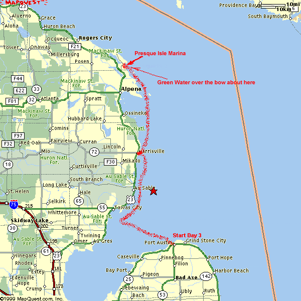
Three - Port Austin to Presque Isle MI (Monday, August 4)
Got Juan up at 7:00 AM, we drop the lines off the dock at 8:06 AM.
It's still overcast, but the rain has
stopped. We talked to Mario, who was berthed in the slip across from
us. He and his family were going to go to Harrisville today too, but later in the day as he thinks it's going to rain some
more.
The trip across Saginaw Bay wasn't bad, one to two foot
waves. We were able to run nearly full throttle for the whole trip. This leg is
the only leg we were on that took us out of sight of land. By now we had a
degree of confidence that the GPS would guide us on our predetermined
course. Then, either a little bit of Selective Availability or some other
anomaly caused the GPS to act strangely. I just kept the same course by the
compass and after a couple of minutes the GPS settled down and we were back on
course.
We pulled into Harrisville at 10:46 AM. It's a little breezy, but the lake was pretty flat.
This leg was 48.6 miles in 2.5 hours. There's only one restaurant open in Harrisville on
Monday, so that's where we had lunch.
We departed Harrisville at 12:55 PM, we're heading towards what we called the Black River
waypoint (44 49.90N 083 15.00W). From there we'll make the decision to either
go to Alpena for the night (17 miles across Thunder Bay), or continue on to Presque Isle.
At 2:05 we arrive at the Black River waypoint, Lake Huron has presented us with one
to two foot seas for the last hour, and it seemed like it would be the
same all the way to Presque Isle. We idled the boat to look at the charts,
it was about 35-40 miles to Presque Isle, and we had been averaging about 20
MPH. We looked across Thunder Bay again, thought it was a little too early to quit for the day,
and made the decision to go on to Presque
Isle.
We figured we could make the run to Presque Isle in about an hour and a
half or two.
I turned
the helm over to Juan as we left the Black River waypoint. The sea
state was still one to two foot waves. Juan was still driving
the boat when the waves increased from the one to two to two to three foot seas. We cut
the speed down and changed drivers. Between North Point and Thunder Bay Island the seas
really picked up, and soon we're heading into six to seven foot waves. I reduce our speed to
minimum steerage (five to seven miles an hour), and set the trim to extreme bow up. We're
taking a lot of spray, but the waves are directly on our bow, and the wind is slightly
from our starboard. I'm getting sprayed a little, but ducking behind the windshield keeps me
mostly dry except for my right arm.
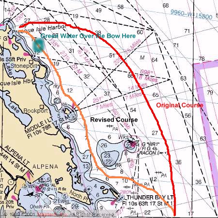
Our original course was plotted to be five to ten miles off shore, and was to take us
outside a series of small rocky islands near the Michigan shore. As the sea state
kept getting worse, I made the decision to change our planned and plotted course.
I wanted to get closer to shore hoping to find quieter water. We have a few anxious moments while Juan was plotting a course
through the small islands and around some charted shallows, but we make it through those
shallows OK.
The boat wasn't pounding hard, but the roller coaster effect of riding up and down made reading the chart, estimating a bearing, plotting and setting a course to
steer, and inputting new waypoints to the GPS made me proud to have Juan as the navigator.
The waves are still six to seven feet high on our revised, closer to shore,
course, and our speed is still five to seven miles per
hour. We're not shipping any water, but the task of keeping the bow to the waves, and
making so little headway, is making this leg of the trip very long, tedious, and tiring.
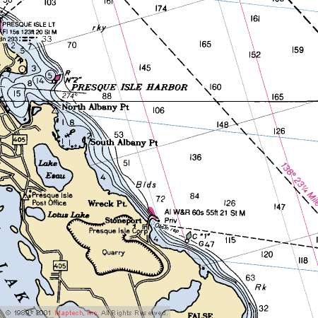
We look at the Stoneport harbor of refuge. (See
link for chart) There are a few problems with going into
that harbor. I would have to turn beam to the waves, and I see a lot of old pilings and
dolphins. (Dolphins are a bunch of pilings lashed together with cable.)
As this harbor usually services lake freighters, there are no small boat
facilities. We would have to tie up to a dock that was 928' long and a deck
height of 12'. On a calmer
day, maybe, with large waves and limited maneuvering speed, going into Stoneport doesn't
seem like a good idea.
Passing Stoneport, we can now see the old Presque Isle lighthouse. We are almost there.
I asked Juan to call the Presque Isle harbormaster on the cell phone and get us a slip, by now it's about 6:15
PM and we don't know how full the harbor is. Just as Juan connects to the Presque Isle
harbormaster, I pull back on the throttle so Juan could hear the cell
phone.
Throttling back
causes the boat to slow enough to change the trim from bow-up to about level. What a
sight as the bow leveled with the top of that six foot wave. Immediately I see the bow
take the top 18" of water off of the next wave. I had enough time to look
toward Juan and yell, "GREEN WATER"
as the wave broke over the bow cover and washed, still a full foot of water high, over the
windshield. Once past the windshield, the water dropped directly on
us. Juan mutters into the phone "forget it" and gives me a look that
asked, "WHAT THE HELL WAS THAT?" Instantly I throttled up, the
outboard responds, and we only took that one wave. (Which was more than enough) I
absolutely should've known better, but I am a fast learner.
I broke the tension by laughing as I switched on the bilge pump. I was laughing
because for the last four and a half hours I was doing my best to stay dry by ducking the
spray of the waves as we headed into them, and I was really doing pretty well. All
that effort was wasted, as now we were both thoroughly drenched. We could not get any
wetter. To add insult to injury, we were only a half-hour (3-4 miles)
south of the Presque Isle harbor
when I did this.
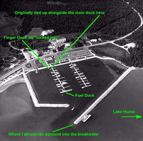
On finally entering the harbor, I get a little too anxious to get away from the waves and
out of all these wet clothes and I swing in too close to the opening in the
breakwater. The water is crystal clear. Below us are some very big rocks, and
they're really close. I spin the wheel, cut the throttle, and manage to miss them
all. After the previous five-hour ordeal, we're happy to be inside the shelter of the
breakwater.
We arrived at Presque Isle at 7:07 PM. Five hours of pounding since we made the
decision to go on to Presque Isle instead of Alpena. Five hours to travel only about 40
miles. I paid for the gas with wet $20 bills. There are no slips available, but being only
21', the dockhands let us tie up at the shore end of one of the docks. Odometer
on the GPS reads 100
miles since Port Austin.
The weather at Presque Isle is beautiful. Probably about 80 degrees. The lake was
brutal, but you'd never know it by sitting in the harbor. We high five at finally getting
docked. After settling down, Juan mentions to me that he saw a couple of sailboats aground
off one of the islands we navigated around.
A little while later two boats full of guys that had limited out on salmon gave us their
slip. One of the two slips was right next to where we were tied up, so we just
pulled the boat over to their vacated slip.
After we got into the "real" slip, a 34' Four Winns pulled in across the finger
pier from us. It was kind of comical at first as he tried to dock, backed out and
then throttling up, he hit the dock so hard that he sent all the college kid dockhands
scattering, along with a few splinters from the dock. We didn't know
it at the time, but that wasn't the last time we were going to see that boat.
We changed into dry clothes, and had a
great dinner in the "Portage Canal Restaurant" and then went over to the
restaurant bar and relived the day's events.
It was great. I've told folks before that the boat will take more than the occupants, and
we proved it again.
Link to Day Four - Presque Isle to Cheboygan (Peaceful trip)