Day
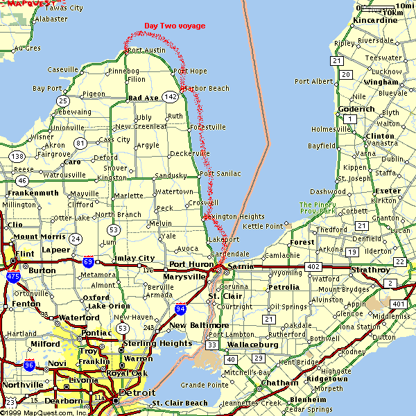
Two - Port Huron to Port Austin MI (Sunday, August 3)
After three months of planning, we still managed to forget something, coffee. We had
breakfast in a little restaurant called "My Place." While there we managed
to buy a package of coffee from the very gracious and sympathetic waitress.
After breakfast I wanted to take a picture of that noisy dammed drawbridge in the open
position. I waited in vain for an hour but no tall enough boats came by to cause the
drawbridge to open.
We departed the Port Huron Marina at 8:45 AM. The current below the Blue Water
Bridges is really unpredictable, with boils and swells everywhere as the three upper Great
Lakes funnel into the Ste. Clair River. We cruise along the eastern shore and
arrive in the town of Lexington at 10:40 AM (43 16.00N 082 31.37N) and
stopped for lunch. We leave Lexington at 11:37 (Juan is keeping the very accurate
logbook.)
As we approach the Harbor Beach breakwater, I notice a larger (35' or so) boat
just starting to go on plane outside the breakwater. We're still cruising at full
speed (about 30-35 MPH) when we hit his wake. I think we both compressed our spines
a couple of inches as we flew over his three wake waves. We "no waked"
into the harbor and arrived at the Harbor Beach Marina at 1:24 PM. A distance of 40
miles in less than two hours. This includes the time needed to tie-up to the
dock. A couple of miles offshore there was a little problem with the adjustable
mount for the Magellan GPS. (It was broke before we bounced over those wakes)
I fixed it with some tie wraps and whipping tape, but it's no longer adjustable.
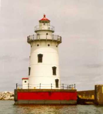
Harbor Beach lighthouse (43 50.74N 082 36.89W)
We left Harbor Beach at 2:18 PM. Somewhere between the Pt. Aux Barques turning light
and Port Austin, Juan dropped a pink can coozy containing a Coke over the side
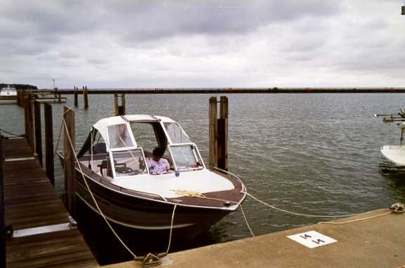
(accidentally, he said) The one he has in his hand in the picture at Port Huron. I
informed him that this was a clear violation of federal law about putting plastic into the
Great Lakes. Unfortunately it was lost and presumed sunk.
It started to lightly rain outside the Port Austin Reef Light. The approach from the
east takes a course that puts you five or six miles offshore and we charted a course
at least a
mile outside the Port Austin Reef Light. Finally we rounded the Port Austin Reef Light and
bear south towards the breakwater. Through the mist and rain we see what we thought was the
blinking of the breakwater light. As we got closer we found out that what we were
seeing were car headlights turning at the intersection just inshore of the marina. We
consult the Richardson's Chartbook and called the marina listed on the chart for a
slip. The Richardson's Chartbook had the phone number for a Grindstone City Marina
erroneously listed as being in Port Austin. After a few minutes of confused
conversation with that marina, we figured out that we were about six miles away by land and about fifteen
miles apart by water. We ended that conversation, and pulled into the Port Austin
Municipal Marina. By now the rain was really coming down, and all the canvas wasn't up.
We got the rest of the canvas put up and tied up in the rain at the last slip available (#14) in Port Austin at 4:20 PM.
That slip is on the outside towards the breakwater, which is the slip with the most wave action.
This slip was also right next to the fuel dock. The damping effect of all the other boats
between the breakwater opening and where one is moored the makes the inside slips more
desirable from a "rockiness" standpoint. But as it was the last available slip,
it was better than nothing.
Port Austin Municipal Marina (44 03.23N 082 59.62W) Sunday morning, notice
the gray skies.
Berthed across from us was this 65 footer that had lost both rudders and both props by
running aground inside the Port Austin Reef Light. Volunteers from the marina and a
commercial fishing boat were enlisted to tow this boat in. Maybe when spending $1.5 mil on
a boat, looking at a $10 chart was beneath him.
We walk directly down the pier and into a nice little bar with cold beer and good
hamburgers. I called Harv Larabell, who only lives a couple of miles away, and he joins us
for a little while. Later we meet Bad Billy from Bad Axe.
In one of the conversations in the bar, Juan asks me what "green water over the
bow" was. I told him it was a little hard to explain, but he would know it if
he ever saw it.
We closed up "The Landing" at 2:00 AM
and walked back to the marina. The rain has stopped,